Southport Eastern Access Improvement Scheme - PUBLIC ENGAGEMENT
Feedback updated 24 Apr 2024
We asked
Feeback on Southport Eastern Access Improvements Scheme – We Asked, You Said, We Did.
A public consultation was held on the Southport Eastern Access Improvement scheme in two stages. Both stages used the same information, with key stakeholders being offered a meeting or in person visits to discuss elements of the plans in more detail.
Stage 1 – Focused on key stakeholders identified by the Council, and those who have an interest in the land on which the scheme will be delivered, either through a freehold, leasehold, or statutory undertaking.
Stage 2 – Wider public engagement. This ran from 3rd November to 23rd December 2023.
The Southport Eastern Access improvement scheme area is on the eastern approach to Southport Town Centre and is recognised as having a mixture of light industrial, retail, and residential uses. The area can experience traffic congestion particularly at peak hours and on days when significant numbers of visitors travel to the town. It also and has limited walking and cycling (active travel) links. This can cause traffic delays and air pollution, as well as limiting the accessibility of employment and leisure opportunities for those choosing more sustainable modes of travel. The aim of the scheme is to therefore to tackle these issues and create safe walking and cycling routes whilst also improving traffic conditions. This will enhance safety, the overall public realm and attractiveness of the routes/area.
We asked for comments of the proposed changes for the eight junctions and walking and cycling improvements.
Since the public consultation, the Council have agreed on the phasing of how the scheme will be delivered. The phases are below:
Phase 1 – To be delivered in 2025.
- Bispham Road Junction
- Sussex Road Junction
- Foul Lane Cycleway Enhancement (corridor improvement).
Phase 2 – To be delivered in 2026.
- Kew Roundabout
Phase 3 – To be delivered in 2027 (subject to funding).
- Castlemore Junction
- Meols Cop Active Travel
- Hampton Road Tiger Crossing
- Virginia Street Roundabout
- Bridge Street Junction
You said
FINDINGS OF THE CONSULTATION
Within the Your Sefton Your Say survey the public had an opportunity to comment on all individual elements of the scheme. The main findings and answers to some key queries and concerns can be found below:
There were 17 responses from stage 1 and 241 from stage 2 to the online surveys. All have been reviewed and analysed alongside the 16 emails responses that came directly via the Transport Planning inbox, which have been responded to.
We have picked out the key themes and concerns and tried to answer them below:
1. CONGESTION CONCERNS
Overall congestion
A common theme from the Southport Eastern Access consultation was concerns how the proposals may result in more congestion.
Congestion during construction
Another theme related to congestion was the impact on journey times as part of the construction phase.
2. SAINBURY’S
The new Sainsbury’s Southport superstore is planned to open February 2024 and will add a new supermarket offering for Southport residents. The consultation responses raised concerns how the new store may add further congestion to the Kew Roundabout area.
3. DISPLACED PARKING
Displaced parking was raised as a concern from the consultation throughout a couple of the junction improvements.
4. ACCESS TO PROPERTIES
Comments were received from properties that proposed plans would amend vehicular access to properties.
5. FLY TIPPING
Fly tipping had been raised as a concern with plans associated with Foul Lane being closed at Castlemore junction.
6. ENVIRONMENTAL IMPROVEMENTS
- Comments were received for concern of loss of trees and greenspace.
- Noise and air pollution were raised in consultation responses.
7. BISPHAM ROAD
- Comments were received that fully segregated cycle lanes should be proposed instead of lightly segregated cycle lanes which the Council are looking further into.
- Concerns that the Bus 46 (Russel Road – Carr Lane) will be impacted by the proposed banned left turn from Norwood Road to Tithebarn Road were raised.
8. SUSSEX ROAD / NORWOOD ROAD
Comments were received by residents that the proposals do not go far enough for improving cycling and walking infrastructure along Norwood Road.
9. FOUL LANE CYCLEWAY ENHANCEMENT
Comments were received that the proposals of opening up Foul Lane to vehicles will result in rat-running as motorists try to avoid Norwood Road / Meols Cop Road.
10. KEW ROUNDABOUT
Comments were received regarding making Kew Roundabout a signalised junction to improve the flow of traffic and to hopefully make for safer driving conditions.
11. CASTLEMORE JUNCTION
Comments were received for Foul Lane to remain open at the Castlemore Junction for vehicles, and not just solely for walking and cycling.
12. MEOLS COP
Comments were received from businesses and residents how the proposed plan will directly impact parking.
13. HAMPTON ROAD
Comments were received that the proposed cycle infrastructure and one-way road layout arrangement on Hampton Road will directly impact access to properties.
14. VIRGINIA STREET ROUNDABOUT
Comments were received regarding pedestrian and cycling crossing infrastructure at Virginia Street Roundabout. It was for proposals to go further with having a zebra crossing on all arms of the roundabout and not just the St James Street arm, improving safety and access for all directions.
15. BRIDGE STREET JUNCTION
Comments were received that proposals do not improve walking and cycling infrastructure at similar levels to other junction improvements. For example, active travel infrastructure should be prioritised over on-street parking, to encourage alternative forms of travel.
We did
1. CONGESTION CONCERNS
Overall congestion
Proposals for SEA have been designed to both improve conditions for motorists as well as walking and cycling. Traffic modelling has been undertaken for all key junctions. There is an intention to create a parallel route for traffic along Foul Lane and Wennington Road, which should both ease congestion and improve this route for cyclists.
Congestion during construction
Sefton Council appreciate that during the construction phase period an increase in congestion may be experienced by some road users. Construction is to be carefully phased and organised with other developments / planned works to reduce the delays in travel time.
2. SAINBURY’S
The Council has undergone traffic modelling to confirm roads have enough capacity. The development has its own transport assessments undertaken as part of the planning process
3. DISPLACED PARKING
This will be further considered as part of the design process and fed back accordingly to designers and was mainly in relation to Haig Avenue and phase 3 improvements.
4. ACCESS TO PROPERTIES
Sefton Council are aware of these comments and are contacting property owners to find workable solutions. It should be noted that the Council are prioritising properties which fall within earlier phases to be contacted first. A vehicle tracking exercises will be undertaken to confirm that vehicle access meets all standards.
5. FLY TIPPING
The Council are considering with designers’ ways in which areas can be planned to minimise fly tipping.
6. ENVIRONMENTAL IMPROVEMENTS
The Council are in discussions with Green Sefton around the whole scheme including trees. In addition, this scheme is one of the first schemes to be going through a carbon assessment process which will include the consideration of trees and the need to mitigate this and replace / replant.
7. BISPHAM ROAD
- The Council are looking further into where light and fully segregated cycle lanes / infrastructure are appropriate. It should be noted that some areas of development are constrained to the available space / width of the highway.
- Discussions have been held with Merseytravel regarding the whole scheme and these improvements will not affect the bus routes.
8. SUSSEX ROAD / NORWOOD ROAD
Enhancing cycling connectivity along Norwood Road was investigated by the Council. This route was not deemed appropriate due to carriageway width and the principle nature of the road, in that it’s a main road connecting the north of Southport to Kew Roundabout. A more appropriate parallel route was agreed to be safer, this being Foul Lane Cycleway Enhancement and up Wennington Road.
9. FOUL LANE CYCLEWAY ENHANCEMENT
The Council are aware that reopening Foul Lane up to vehicles will inevitably result in surrounding roads experiencing vehicles, this being the reason mitigation measures are currently being developed for Norwood. Measures will be agreed with Ward Members and the community. The Council have undertaken modelling for these proposals and further modelling will be done as part of developing the final designs and business case. Mitigation measures will be implemented before Foul Lane is opened to vehicles.
10. KEW ROUNDABOUT
Making Kew Roundabout signalised to improve the flow of traffic has been taken onboard and is being investigated by the Council.
11. CASTLEMORE JUNCTION
Castlemore Junction is to be delivered in phase 3, 2027. Sefton Council have taken feedback onboard and are using this to inform further designs.
12. MEOLS COP
The Council are looking into achieving safer streets for school pupils while minimising the impact onto the local community. Sefton Council are keen to accelerate delivering Meols Cop School Active Travel improvements in an earlier phase, but this is subject to funding.
13. HAMPTON ROAD
Different cycle lane and one-way road layout arrangements are being considered for Hampton Road so that access to properties is minimised. The Council are also in communication with both the school and church regarding this.
14. VIRGINIA STREET ROUNDABOUT
One of the main aims of this scheme is to improve conditions for both cycling and walking. The Council welcome comments of how conditions of the proposals can be further improved. Comments relating to more zebra crossings have been fed back to the design team accordingly. It should be noted that the scheme has limited funding available. However further ideas could form part of the mitigation process and / or future schemes in the area.
15. BRIDGE STREET JUNCTION
Bridge Street Junction is to be delivered in phase 3, 2027. Sefton Council have taken feedback onboard and are using this to inform further designs.
Results updated 24 Apr 2024
Overview
Sefton Council are improving our streets and transport network to support our Sefton 2030 Vision, throughout the whole of the Borough of Sefton.
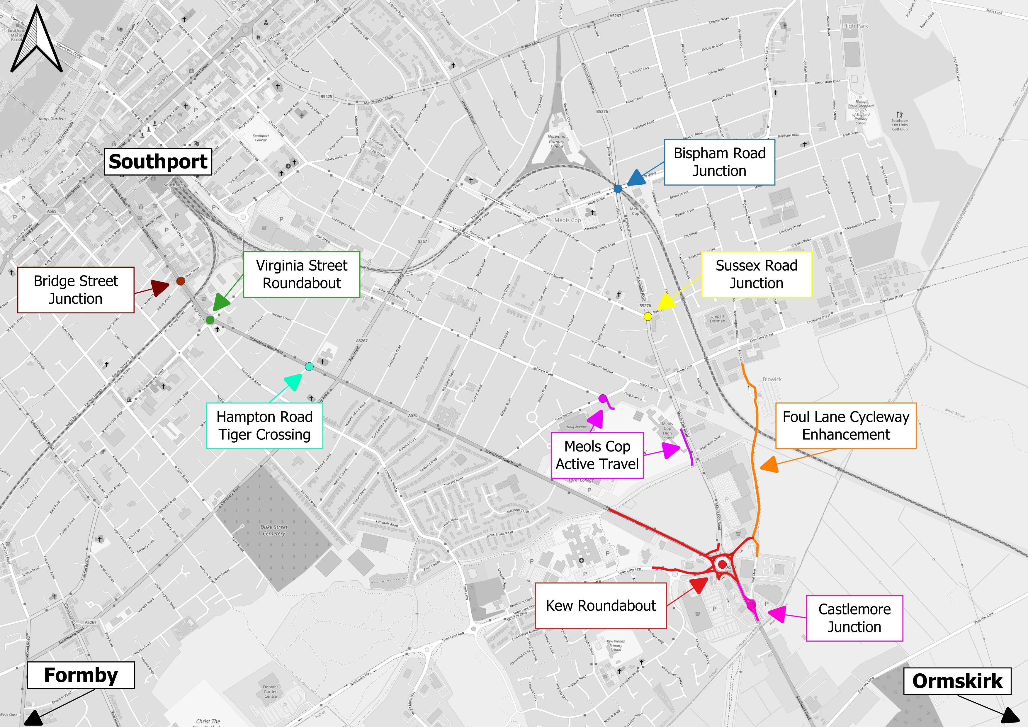
The Southport Eastern Access improvement scheme spans from Eastbank Street / Bridge Street to Kew Roundabout and connects to Foul Lane and Meols Cop Station. Our scheme is focused on introducing new and upgraded junctions and active travel (walking and cycling) routes along Scarisbrick New Road, Southport Road, Kew Roundabout, Foul Lane, Meols Cop Road, Norwood Road and Haig Avenue. We want to make it easier for vehicles, cyclists and those walking to move around the area.
The improvement scheme has been split up into several sperate areas, where we will improve junctions and walking and cycling accessibility.
- Bridge Street Junction
- Virginia Street Roundabout
- Hampton Road Tiger Crossing
- Kew Roundabout
- Castlemore Junction
- Foul Lane Enhanced Cycleway
- Meols Cop School Active Travel Access
- Sussex Road Junction
- Bispham Road Junction
The Map below shows the walking and cycling improvements as well as the junctions which are going to be improved.
Southport is recognised as a key area in the borough’s plans to grow the economy and better public spaces and transport networks will help towards this. The Southport Eastern Access improvement scheme will improve the road network, footways and cycling routes between the town centre and the Southport Road border in Kew.
Our plans would look to improve the overall conditions for all users including drivers, walkers and cyclists. Our plans will help to tackle congestion issues for motorists and "rat running" on key routes to and from Southport town centre, including Scarisbrick New Road and through the local area including Norwood Road, Meols Cop Road and Butts Lane. Our plans will also help to improve access to Kew Retail Park and the wider area and the industrial units on Crowland Street and to update walking and cycling paths at the eastern side of the town.
The Southport Eastern Access improvement scheme gives us the chance to develop traffic calming and safety measures as well as to improve the overall look and feel of key public areas as part of an additional scheme. We will work with the community to put these further measures in place to make sure that traffic use the main roads rather than travelling through the residential areas.
Copies of the plans for each of the nine sections of the scheme can be found on the individual pages or at the bottom of this page in the Related Documents section.
We have an Easy Read version of this consultation.
Why your views matter
Following the initial engagement with local residents and businesses and the wider public in Spring 2022, the Southport Eastern Access improvement scheme designs have now been further developed. The initial designs have also been reviewed by Active Travel England, who are the national government review body for the walking and cycling elements of all highways and transportation schemes.
The Liverpool City Region Combined Authority's (LCRCA) has now secured funding from the Central Government’s City Region Sustainable Transport Settlements Fund, and Sefton Council are developing a Full Business Case to help secure some of this funding for the scheme from the LCRCA.
As part of this process we are undertaking further engagement on the updated scheme designs. We have already started talking to key stakeholders who may be directly impacted by the improvements and we are now launching a wider, public facing campaign. We welcome all feedback and want to hear your views.
What happens next
This is the second stage of consultation on the detailed design of the scheme. The results will be analysed and all comments will be taken back to the design team.
Areas
- Kew
- Meols
- Norwood
Audiences
- Anyone from any background
Interests
- Home page
Share
Share on Twitter Share on Facebook